Understanding Oregon's Last Remaining Old Growth Forests
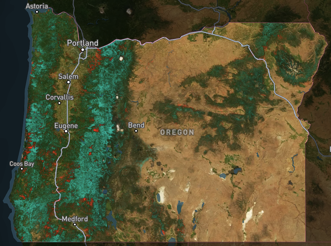
Check out the map of Old Growth here.

Thinking about Oregon’s Old Growth
During my time as a software engineer at Pachama, a climate technology company in the voluntary carbon markets, I developed some familiarity with forest conservation policies and the economic and environmental factors that drive deforestation. However most of this time and experience was in Latin America, especially Brazil, due to the keystone importance of the Amazon rainforests as carbon sinks and biodiversity treasures in the context of carbon markets.
I also wanted to understand deforestation and the timber industry in my home state of Oregon, so I set out to answer two basic questions:
What is Old Growth?
Old Growth forests are special. Although the precise characterization of what constitutes “Old Growth” is perpetually in question, we know that these forests fulfill unique and crucial roles as carbon sinks, biodiversity havens, and cultural resources. In Oregon, we have around 3 million hectares (~8 million acres) of Old Growth. This is a substantial and grand portion of the United States’ overall last remaining Old Growth forests. According to the USFS, the U.S. has around 10 million hectares (~25 million acres) of Old Growth remaining.
Where is the “At Risk” Old Growth in Oregon?
Constant vigilance is required to ensure the preservation of these forests everywhere, but is especially important on private lands. While harvesting of Old Growth on public lands can occur, public lands enjoy greater environmental protections, and the vast majority of timber harvests occur on private lands. Therefore, I concluded that Old Growth located on private lands could rudimentarily be considered “At Risk”, or minimally, “at greater risk of harvest than that located upon public lands”.
Based on data of Old Growth in Oregon from 2012, of the around 3,450,000 hectares of Old Growth in Oregon, 630,000 hectares (18%) are located on private land. While there are some protections for Old Growth, even on private lands, such as the Endangered Species Act (ESA) and the Oregon Forest Practices Act (OFPA), these forests can often be cut down under claims that they are not Old Growth. This happened as recently as 2019, to public outrage, at Oregon State University, to say nothing of the harvesting that goes unnoticed. Moreover, timber interests have every incentive to feign ignorance and perform only cursory classification and field surveys, to not interfere with their harvesting designs and profits within their purchase areas.
Contrary to the misleading claims of the Oregon Forest Resource Institute (OFRI), whose board is heavily populated by timber industry interests, that claims 3 trees are planted for every 1 harvested, indicating the timber harvest is perfectly sustainable, Oregon has actually lost forest cover in the last decade, and not just on account of wildfire. OFRI’s claim is not misleading in the number of replanted trees post-harvest, but rather in how it oversimplifies the forest lifecycle, undervalues the true indirect costs of clearcutting, and overstates the ecological benefits of new plantings. Juvenile forests cannot compete with the unique benefits of Old Growth on sheer forest biomass, carbon capture, and benefits to soil productivity and ecosystem health, so we must especially focus on their preservation.
Putting it all Together
In my inquiry I envisioned something akin to a “real-time” (monthly) monitoring platform, as Stand.earth has done with Forest Eye for British Columbia. However, in the interest of time and resources (Stand.earth partners with Planet for imagery and leverages timber industry data and policies particular to BC), I opted for a far more rudimentary (and therefore less useful) conception to understand the locations Old Growth in Oregon.
The result is a map depicting the Old Growth and “At Risk Old Growth” (Old Growth located on private lands in Oregon), available at anmiller.com/oregon. This site is a NextJS application, the map is a typical Mapbox and react-map-gl setup. I used QGIS for geospatial processing, and I learned quite a lot performing raster analysis and simplifications. For hosting raster tiles, I chose Mapbox Tiling Service for simplicity. While Mapbox can be expensive for non-hobby uses, it was a natural choice compared to self-hosting a tile server due to its simplicity.
You can learn more about the data provenance, methodology, and results at anmiller.com/oregon, and the source code is available as well.
Closing Thoughts
Having worked alongside forest scientists and researchers, machine learning experts and geospatial wizards, I know all too well the limitations of little project such as this. I’ve attempted to cover any disclaimers that came to mind on the map.
The most material limitation of this exercise was that I relied on Old Growth data from 2012, whereas the satellite imagery is from 2024. So in addition to classification of Old Growth likely having dramatically improved in that period, you may also notice some locations where Old Growth is shown in the raster layer but not visible in the satellite imagery. This could be a false positive of deforestation due to misclassification and data quality, but also could actually be a true case of harvesting within the last 12 years.
So, while it’s not great, let alone perfect, this was nevertheless a fruitful exploration that involved learning new technical skills (geospatial processing) and even had some compelling findings about the place I call home.
